Wednesday, April 21, 2021

Buffalo River Trip


Friday I left Fort Collins at 8:30 am, headed for Denver and then East on I-70. It was windy, so hard driving, especially with a boat on the roof. I stopped in Hays Kansas, about 4 pm Denver time, which was my original plan. I stayed in an adequate Econolodge, and ate at Vernies Hamburger house. I was tired. 

Saturday I got going about 8 am, and continued east to Salina, where i turned South. I turned east just north of Wichita on road 400, a good two lane road that was limited access in places. I turned south at Joplin Missouri, and headed for Bentonville, where I had a reservation at the Crystal Bridges art museum. I checked into a Quality Inn before 4 pm, and drove to the museum, to explore the art outside. The grounds are beautiful. 

I ate at Wright’s Barbeque, good and very popular. I walked around downtown a bit, and saw many folks dressed up, presumably for wedding photos. I even saw a wedding in progress outside the courthouse. The downtown is gentrified, and looks good.   Lots of Walton money.....

Sunday I went to the Crystal Bridges museum. Not a lot really struck me in the main museum, although I liked some of the outdoor pieces. The grounds are huge; you have to walk to see all the art. The special craft exhibit did have some excellent work. I had a good lunch outside at the Pressroom. 

I drove two hours to London, to Randy’s house. He rents a pretty good house for less than half what a studio apartment in Fort Collins would cost. He showed me around a bit. Very green, hills, reminds me of Kentucky. He cooked chicken on the grill. I spread out my gear and went through it , I think I am ready to go. 

We drove up to Ponca, and met Jim and Cynthia at Buffalo Outdoor Center at 9. We signed up for the shuttle there, and drove to Pruitt for the put in.  The put in was crowded with day trippers. I spoke to a lady from Houston Canoe Club, she knew John and Anne O. 


Our group, Jim, Cynthia, Randy, and I

We got on the water about 11. We paddled to mile 60 below Hasty Campground, about 8 miles. We scraped some until we got to Little Buffalo River. The river changed character below the Little Buffalo, it got wider and deeper.   We camped in the trees. Randy started a fire on the gravel bar. We found three folding chairs and a set of horseshoes.  It rained most of the night. 

Tuesday, We put our tents away wet, and got on the river 9:45. Jim and Cynthia got their canoe jammed against  a tree limb, after misjudging a cross current. Randy was able to pull the canoe loose, but it was full of water. Luckily, no one was hurt, with nothing lost but a paddle, which Randy found downstream.  The day was sunny and nice. 

We saw a turkey, many blue winged teal, and a bald eagle swoop down to the river to get a fish. 


We paddled pretty steady until 4 pm, and covered 14 miles to about mile 74. We saw no other boaters all day. We cooked and ate facing the river, on a gravel bar. 

Although it was clear earlier, it rained most of the night, sometimes hard. 

Wednesday. When we paddled by Richfield creek, it  was muddy and high, and the river changed character again, now muddy with water in the trees, like it was in flood.   We paddled to about mile 85, so 11 miles. We camped on a sand bar, but high enough to protect us if the river rose a few more feet. Randy started a fire and told stories. We talked to one guy in a car today, but saw no other boaters. It rained some overnight. 

Thursday. The sun was shining in the morning. The forecast was for rain that night, and all day Friday. We decided to come out a day early. We got in the river about 10 am, and reached the takeout before 2 pm, after a lunch break. 14 miles in 3 hours, 5 mph, despite a headwind. The high water meant fast current. We saw several boaters that day. 

Randy and I had fried catfish at Hillbilly Slims;  we got a tour of the commercial wood shop in back. 

Friday was on and off rain. Randy drove county roads and showed me his paddling spots. We fished some, no luck. Randy drove me to the dam on the Arkansas that creates Lake Dardenelle. 

Saturday we ran Big Piney Creek from the state park to the Moore Outdoor center. We had a quiet paddle, spent a long time socializing afterwords.  People were just glad to be able to talk face to face after a long covid winter.  Randy has known the Moore’s for 30 years. 


Sunday I said goodbye to Randy, got on the road before 8 am, and stopped in Shamrock Texas, a town with a Route 66 theme, including a 1930’s art deco gas station with a Tesla charging station in back.  The town is an odd mix of old junk and new murals.   I stayed at the retro but nice Shamrock Country Inn, 1970s style.


Monday I got on the road at 7:30, stopped at the Cadillac Ranch art installation in Amarillo, and then pressed on through wind to the Sand Creek Massacre site. I stopped in Limon at the Quality Inn after 10 hours of driving; I was tired.  It was snowing in Fort Collins, and cold in Limon.  

Tuesday there was about an inch of snow on the car, and the road reports were not good.   I went back to bed, and left the hotel about 10 am, after the sun had melted the ice on the roads.   The drive home was straightforward, with roads that were wet and dry, but not icy.


Saturday, April 3, 2021

400,000 Cranes

 Sandi was able to get a slot at a blind on the Platte River to see the hundreds of thousands of Sandhill Cranes who spend time there every spring.    

On Thursday we drove partway, to North Platte, where we stayed in the Husker inn, owned by an Asian family.   A modest motel, but super well kept.  We had trouble finding outdoor seating for dinner; we later realized that in Nebraska, people don't sit outdoors to eat, even at fast food places.  We finally found take out at a Mexican restaurant.

Friday we drove to Kearney, where they claim the title of Sandhill Crane capital of the world.   We checked into the New Victorian Inn, a renamed older motel, and then drove around looking for birds in the fields.   We would see one group, then another, and some very large groups, too large to count, eating what was left after the fall harvest.   The birds are working to gain energy to head for northern Canada, or even Siberia.   


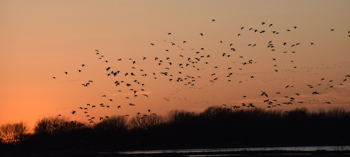
We arrived at the Nature Conservancy house an hour early, but our guide, Kate, was there to greet us, and gave us a tour of the shop.  She is a fellow, a kind of intern, very happy to be there;  she will be there for a year.      We drove to the river, and then walked to the blind, next to the Platte river.   The sun gradually went down, and we could see some birds flying, but none of the birds landed.   After the sunset, birds started to land, in a steady stream, which we understand includes miles of river.  Our blind had a large sand bar in front of us, and the sand bar gradually filled up with birds.   Any photos only show a very small part of the sea of birds.   It is almost a primeval event.


Our guide came and got us once it was fully dark, walking us back to our car using a red lantern, so as not to disturb the birds.

Our drive back on Saturday was routine.    Sandi had never seen the type of sign below, which Richard has sometimes seen in far eastern Colorado ranch areas.    It gives you a sense of how spread out the ranches are; directions in terms of miles rather than addresses.   We were unable to find information on the Eureka Club. 


Sunday, March 28, 2021

Canyonlands Park, Moab, and Hovenweep Monument


 Our trip started with a 300 mile drive from Fort Collins to Island Acres Campground, east of Grand Junction, next to the Colorado River. We did see a herd of a dozen Rocky Mountain Sheep near Georgetown, but otherwise the trip on I-25 and I-70 was routine. The snow disappeared after Vail. Island Acres was nice, as usual.

We got up and drove to Love's truck stop in Grand Junction, where we bought gas and propane for the RV. Then we drove to the visitor center in Fruita, where Sandi collected some maps and brochures, and Richard did a dump and fill. Then we drove west on I-70, and decided to drive the river road to Moab; it was beautiful, but twisty, and slow. It is definitely more work to drive an RV on that kind of road.

In Moab we parked at City Park, and ate paninis at the Moab Food Truck lot. The town and streets were busy. We strolled over to the bookstore, picked up an ice cream, and got back in the truck. We went off on an ultimately futile search for the small propane cylinders used in portable grills. Between going into stores and calling, we must have hit a half dozen places, but no luck.

After getting gas, we headed south to the Canyonlands Needles district, another twisty road with a lot of up and downs, so slow and hard driving in an RV. We entered the park, and found the turn off to the Needles Outpost, an off the grid place where the most important amenity is coin showers. We tried to get into one site, ultimately gave up, and found one that worked. By the time the camper was parked, it was 6:30, and Richard was tired. The views west were great, and we were camped right next to some interesting rocks. We talked to some young men who rented a tent on a platform that was listed on Airbnb. The décor was Arabian Nights; the cool amenity there was a sofa facing the sunset. We had planned to move to a BLM campground, but decided that we liked the Needles Outpost, and that the location was very convenient.

View of our campground

On Sunday morning, we went to the office to pay for a couple more nights. The owners are from Texas; they bought the park in poor condition a few years ago, and have been gradually improving it, mostly with their own labor. After stopping at the Park visitor center, we took a short walk on a trail to see an ancient grainery. We checked out the NPS campground, and found that the sites there were small, with only a few large enough for our rig. We took the pothole trail, which had nice views, but would have been more interesting if the potholes were full of water and life. The Needles rock formations were very impressive, formed by cracks created by motion in the supporting salt layer, 1000 feet below.
The park was busy, with several parking lots full, especially at trailheads. The Jeep crowd were lined up to start up Elephant Hill, which had an intimidating start. We headed outside the park to look for a viewpoint that a ranger had mentioned. After opening a wire gate, we were forced to go to four wheel drive. We parked near a cattle tank, strolled up the jeep road a bit further, and decided that the broad vista was not as attractive as other views inside the park. Sandi noticed many BLM road marker posts had been pulled out. We headed back to the camper, and Richard took a nap. Sandi cooked over a fire that Richard made. We had hoped for sunset photos, but the sky was overcast, so we toured the campground, and Richard climbed some of the rocks behind the campground.

On Monday, the park was much less busy. We took a short hike to the Cowboy camp, where we also saw a spring and rock art. We stopped for a picnic, and had a chat with one of the maintenance guys picking up trash; he was from West Virginia, and was happy to be on full time. We took a longer hike on the Slickrock trail, mostly walking on rocks. This trail has overlooks and great views of the canyons. Sandi cooked dinner over an open fire.

On Tuesday we got on the road about 8 AM, early for us, and stopped at Newspaper Rock to see the rock art there. In Monticello we were able to dump and fill, buy water bottles and gas, all at the Maverik, one stop. We proceeded to Edge of the Cedars State park in Blanding, which is a museum devoted to Ancestral Puebloan culture (Anasazi). It was a very good museum, driven by local interest and support. The glass wall storage area let us see a larger part of their collection. There is also a small archaeology site behind the museum. Their prize item in the collection is a Macaw feather sash, still brightly colored, demonstrating the extensive trade networks of the era. There were a series of exhibits showing how people reported finds to the authorities, so that they could be properly documented an preserved. We had lunch at Yak's Center Street Cafe, where we were able to order diner food without going inside, and have it delivered to our truck. It started to sleet and rain.

We had written directions on how to get to Hovenweep, but the directions were not as clear as they should have been, especially with respect to road names and signs. We drove through the Ute and Navajo reservations, and saw small herds of horses that we believed to be wild. The Hovenweep Visitor Center is closed midweek, but we were able to get a campsite. The rain continued into the evening.

There are several ruins in this photo, including one under a boulder.

On Wednesday, we woke up to snow and sleet. The roads were wet. We took a walk to the edge of the canyon to admire the ruins and take some photos. After reviewing the weather forecasts in various places, we read that the weather at Hovenweep was not going to improve. We decided to retreat to Moab, which had better weather. We drove back through Blanding, had another lunch at Yak's, and went to a fancy RV park in Moab, Spanish Valley RV. We read about some music downtown, and watched some pretty good local musicians play bluegrass in the evening. It was a small outdoor venue, an empty lot behind a restaurant. We did enjoy the music, walked to get ice cream, and headed back to the RV.

Castleton Tower

Thursday we decided to wander around. We headed towards Castle Valley, a small community rich in authors and environmentalists, including Terry Tempest Williams and Craig Childs. We happened to run into the town clerk, who told us some of the town history. It was originally a ranch, was divided up, and later incorporated as a city. This is around 30 minutes from Moab. We took photos of Castleton tower, and headed towards Fisher Towers, a very popular hiking and climbing destination. We had a picnic lunch there, and headed back towards Moab, and then crossed the river to find the road to Potash. At the end of the road we found a boat ramp, and a couple of NPS employees working on the ramp. We were directed to the best outhouse in the Moab area, extensively decorated by a local artist. Richard asked about campsites on the river, and we chatted with the rangers. We headed back to the RV, through heavy Moab traffic, and then to Antica Forma for a nice Italian dinner. We were hoping to see another concert, but it was canceled by the weather; it started to rain about the time we arrived. We had another ice cream. It rained hard that night.

Friday was our day to move to the Grand Junction area, Island Acres Campground, part of the state parks system. We bought fuel, propane, and RV parts in Grand junction, and ate Mexican food at El J's in Clifton. Sandi laughed at the street names in Grand Junction, such as F ½, 23 and ¾, an 23 and 1/10th. We got settled into the campground, and Richard decided to check out the nearby Cameo Shooting Complex. This is a very large area, with sporting clays, outdoor pistol and rifle ranges, as well as an archery range. This areas was formerly a coal powerplant, and is run by Colorado Parks and Wildlife. Many groups came together to buy and build this impressive facility.

Saturday we drove back home, through some snow in Frisco and the tunnel.

Saturday, November 28, 2020

State Forest State Park


The curiously named State Forest State Park is about 2 hours west of us. Since we were not going anywhere for Thanksgiving, we decided to go camping.


The drive up the Poudre Canyon allowed us to see some of the devastation from the Cameron Peak fire, the largest fire in Colorado History. Many of the areas that we had hiked in the past were closed. 


 As we got close to Cameron Pass, the road became snowpacked. We went over the pass, past the Moose Visitor Center, and turned at the North Michigan Reservoir turnoff. I engaged the 4WD, due to the snowpacked roads. We had some trouble finding our campsite; we missed it the first time, and had to turn around. The campsite is very close to the dam. When we have stayed at the park in the past, we have been on the other side the reservoir, but that road is closed.


The moon rising over the mountains.


After we got the rig parked, we went for a hike on the beaver pond trail. The first part was nice, but then we got into an area that had been logged, with tree trunks blocking the trail, so we turned around.


As the evening went on, we watched the outside temperature go down. By 8 pm, it was 7 degrees outside. The furnace was running almost continuously.


In the morning it was -2 F, very cold. The camper continued to work, and it was not uncomfortable inside. However, the battery had dropped to 35% charge, having started the evening at 85% charge. When Richard started the generator, it was leaking gas a lot, so he shut it down. No way could we withstand another night of very cold weather without plugging in, or running a generator for a few hours. We stopped and asked about a campground where we could plug in, but no luck. We decided to take a hike and head home.


We drove to the end of the park road, and hiked on the North Canadian trail. The trail was packed down by tracked vehicles; when we went out of the track, we found somewhat difficult going, so we stayed on the track. The snow was not deep in most areas, except for north facing slopes. After hiking for an hour or so, we headed back to the camper, hooked up, and drove back to Fort Collins, getting home after dark.


We did learn some things. One is that if we are going to be camped in zero degree weather, the camper needs to be plugged in, or we need to plan to run the generator for several hours. The other is that the generator needs to be fixed or replaced. I bought the generator years ago, used, so it is perhaps 20 years old.


It was sunny, snowy, and beautiful. We will have to do it again.


Saturday, October 24, 2020

Canyonlands and Mineral Bottom


 On Thursday we packed up and left the commercial campground. We arrived at the BLM Horsethief campground around 10 AM, only to find no empty campsites. We talked to a couple who were about to leave, and ended up in their campsite. It is right next to the dirt road, but beggars can't be choosers.


After setting up the camper, we decided to go to Mineral Bottom, which turned into quite an adventure. Two young men had a shredded tire on their van, and their jack would not lift the van high enough to change the tire. We found out they were highliners, which we understand to be slackliners, but further off the ground. Between the truck jack and a wood block from the truck, Richard was able to lift it high enough to get the job done. They were surprised that several people stopped and asked if they needed help, even after we were already stopped.


Two of the switchbacks


Mineral bottom is 13 miles of dirt roads, to the edge of the cliff. The road goes over the edge and then back and forth along the side of the cliff, with occasional switchbacks. Sandi was scared to death. We made it down, and enjoyed the scenery along the banks of the Green River. 


After a lunch break, we decided to head south on the White Rim road, which follows the river. We drove a few miles, and turned around before we got into Canyonlands Park. As we were returning, we found four college age girls who had stuck their rental car in the sand. They were attempting to dig the wheels out with their flip flops and a frisbee! After reviewing our options, Richard decided that their best option was to jack up the front wheels, put rocks under them, and then wood and rocks behind them. Richard had a wood block to put under the base of the jack. Once we were ready, one girl drove and everyone else pushed. It worked! I am not sure that I recall rescuing two different groups in the same day, but Sandi said we did our kind thing for the day. Maybe for two days. We got back to the camper about 4, and rested before dinner.


Studying the weather forecast for Sunday, we saw that the weather service predicted a major storm and extreme cold. This caused us to rethink our trip plan. We decided to come home early, on Saturday, to beat the storm. In order to do this, we decided to start the drive on Friday, and finish it on Saturday.


Friday morning, we drove into Canyonlands NP, and headed for the southernmost part of the Island in the Sky section of the park. We decided to take the Grand View Point walk along the rim, looking down into the canyons of the Colorado and the Green Rivers. There were many people with the same idea; the views were impressive, and the hiking moderate, about 2 miles round trip. We had considered taking the walk to the Mesa Arch, but that parking lot was full, so we drove back to the camper, packed up, and headed out. We refueled in Grand Junction, and then continued on I-70 to the campground at Island Acres, part of the Colorado River State Park. The campground was pleasant and not crowded; we enjoyed a hike along the river.


Saturday we headed home. The closer we got to Fort Collins, the worse the smoke appeared. The two largest fires in Colorado history are west of us. Luckily the snow should put a damper on the fires.


Overall, a good trip. We plan to return in the future and hike more in Canyonlands. October is a busy month in that area, perhaps another month would be better.


Moab and Arches National Park


On Sunday October 18th we drove to Grand Junction, where we stayed at the RV Ranch. The drive on I-70 was routine, buying fuel in Arvada before we headed into the mountains.


On Monday we fueled up, and drove to Moab. Archview campground is north of Moab; we had a reservation for two nights, but were able to get that changed to three nights.


We drove through construction into Moab, and picked up lunch as Sultan's restaurant, which we ate in the town park. There were a lot of camper vans parked there, including people working on their laptops. We walked around downtown Moab, as Sandi had never been there before. Sandi did some shopping. Moab seems more upscale than in the past. The town was very busy, but we were told that October is their busiest month.


In the evening we drove into Arches National Park, which neither of us had seen before. It was very impressive and we took many photos. We plan to return in the morning.


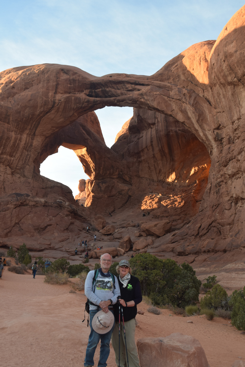
Tuesday we got up very early, and were in the park before dawn. We took some photos of balanced rock at dawn, and took a short hike to see Delicate Arch, the symbol of Arches NP. Then we started to notice full parking lots. After that we stopped at the fiery Furnace, and continued to the end of the road. The area was closed, but we persuaded the ranger to let us through, so that we could check out the campground. The park was filling up, so we left. After a stop at the visitor center and bookstore, we left the park, and noticed that the entrance was closed, too many people. We drove over to check out Horsethief Campground, a BLM campground north of Canyonlands, and found a few empty sites. We also drove further down the dirt road, but the few campsites there were occupied. We did see some oil activity in that area. We continued into Canyonlands park, and stopped at the Green River overlook. We went back to the camper to rest, and later drove to the Windows area in Arches, where we were very impressed with the double arch, which is almost hard to believe. We left as it was getting dark.


Every parking area seemed to have a noisy raven, begging.


Landscape Arch is almost hard to believe.


Wednesday we got up early, and were on the road by dawn. We drove to the Devil's garden area of the park, and hiked to Landscape arch. We stopped on the way to see Pine Tree Arch and Tunnel Arch. By the time we started back, the trail was getting busy, and the parking lot was full. We gave our parking space to a needy tourists, and headed for Moab. Sandi visited the local yarn shop. We had a pleasant lunch outdoors at the Arches Thai restaurant. We decided to drive the La Sal Mountain Loop Road, which starts along the Colorado River, and then climbs 5000 ft to 10,000 ft elevation. The road has more switchbacks that I could count, and many very steep sections. This was new for both of us. We checked out Ken's Lake Campground, south of Moab, on our way back to the campground. The weather forecast is forcing a trip replan, as we don't want to drive I-70 in the snow. We canceled our reservation for Sunday night in Grand Junction, but we may still spend a couple of nights in Grand Junction.


Friday, October 16, 2020

Backpacking in Rocky Mountain Park

 I had not been backpacking for a while, but decided to go on a short backpacking trip in Rocky Mountain National Park.   On Sunday, Sandi and I went to the park, got my wilderness permit, and took a hike.

Monday I drove to the Finch Lake trailhead, in the Wild Basin area, in the SE corner of the park.  The hike up was a grind.  My pack was 45 pounds.  The hike was 5 miles, about 1500 vertical feet up.  I found the official campsite, set up my tent, and cooked dinner.

Mt. Meeker in foreground, Longs peak left of Meeker

Tuesday I hiked and fished my way around the lake.  Unfortunately the fish had no interest in my Kastmaster lure, which usually works.   I am not 100% sure that I even saw fish dimpling on the water, so perhaps there were few fish in the lake, although the reports were of good fishing.     I was frustrated at first, but then settled down to enjoying the place.    The view of Longs and Meeker peaks from the other side of the lake was nice, kind of a unique view, as no roads will give you that view.


Camp Robber or Gray Jay


I had thought of hiking higher, but my boot was starting to come apart, so I did not.  With no fish and a bad boot, I ended up coming out Wednesday, a day early, after two nights, but I knew that was a possibility before I left.   It felt good to get out.  .